
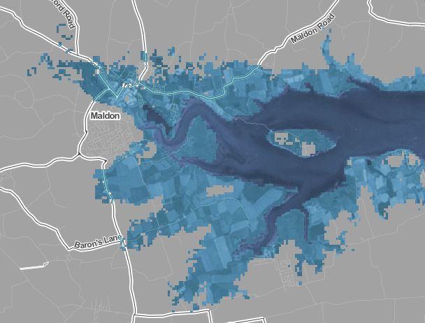
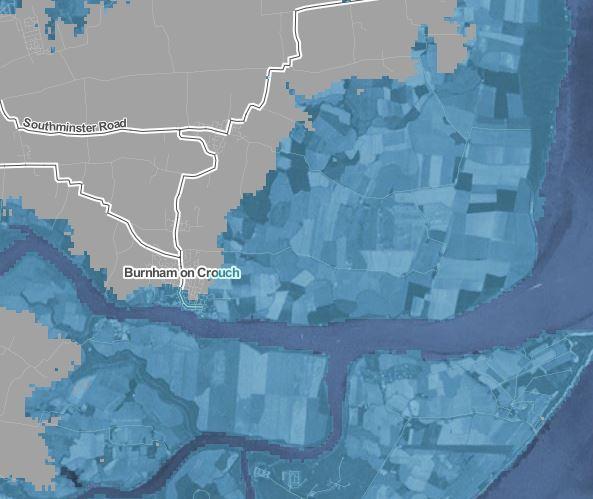

NEW flood risk maps have revealed that parts of Heybridge, Maldon and Burnham could be under water within 12 years.
A report by the Intergovernmental Panel on Climate Change last week revealed how many coastal areas could be submerged if global temperatures rise by just two degrees.
The maps, published by Climate.gov, show that the area surrounding the future 1,138 North Heybridge Garden Suburb could be under water if the 2C limit is reached.
Don Benson, of Heybridge Residents’ Association said: “A flood risk map has been published by a renowned company of scientists and engineers with connections to the UN.
“It reports that if the climate rises by a further two degrees centigrade, the area surrounding the North Heybridge Garden Suburb could be submerged and this could happen during the next 12 years.
“The Government recognises that local people are generally best placed to decide what works in their area regarding surface water flood issues.
“This has been ignored by those who make decisions on the planning applications subjected to Heybridge.
“It has been put forward on many occasions that Heybridge has a very good existing system of ditches, drains and culverts which if maintained in a practical working condition would relieve the area of a high level of localised flooding.”
The new reports follow the UN’s warning last year that there is only 12 years for global warming to be kept to a maximum of 1.5 degrees.
Just half a degree more will significantly worsen the risks of drought, floods, extreme heat and poverty.
Mr Benson added: “In discussions with the Environment Agency, it was agreed that a simple but very practical flood alleviation scheme could be incorporated into the existing system, which includes the very important Langford Ditch.
“Apparently, all statuary bodies involved are having serious difficulties in raising finance to make this happen.
“In the not too distant past, Heybridge has suffered from needless flooding issues and is still in a situation where this could continue.
“We can only hope that the Environment Agency manage to find funds for a flood alleviation scheme.
“With an acceleration in global warming and in increased number of severe weather events it is inevitable that there will be an increase of flooding in Heybridge in the years to come.”
A spokesman for Essex County Council, said: “As the lead local flood authority, the county council has responsibility for flooding caused by rain, surface water and groundwater only.
“When asked to comment on planning applications made by other authorities we will take account of these elements of flood risk, but will also include a 40 per cent allowance for the effects of climate change over the assumed 100-year lifetime of a development.”
“The Environment Agency has responsibility for assessing the flood risk from main rivers and the coast.
“In the case of the North Heybridge Garden Suburb, planning legislation can only require developers to address flood risk caused by the development process.
“Following assessment of the developer’s proposed surface water drainage scheme, we confirmed we had no objections, subject to a set of recommended conditions.
“Historic proposals for a flood alleviation scheme in this area were designed to address existing flood risk and therefore cannot be considered as part of the current planning process.”
The Environment Agency said: “Schemes to defend against flood risk are important to help maintain the sustainability of communities.
“Particularly where those risks are set to increase through the impacts of climate change over time.
“Maldon and Heybridge have extensive tidal flood defences which protect large parts of the low-lying developed areas of the town from regular flooding from the estuary.
“The Essex and South Suffolk Shoreline Management Plan covers the Maldon District and sets out aspirational policies and a long-term vision for how the coast and estuaries should be managed over the next 100 years recognising the challenges of climate change.
“The policy for Maldon and Heybridge is to hold the defence line where it is now with the aim of maintaining or upgrading the standard of protection.”


Comments: Our rules
We want our comments to be a lively and valuable part of our community - a place where readers can debate and engage with the most important local issues. The ability to comment on our stories is a privilege, not a right, however, and that privilege may be withdrawn if it is abused or misused.
Please report any comments that break our rules.
Read the rules hereLast Updated:
Report this comment Cancel